
The Grand Canyon is a steep-sided canyon carved by the Colorado River in the United States in the state of Arizona. It is largely contained within the Grand Canyon National Park, one of the first national parks in the United States. President Theodore Roosevelt was a major proponent of preservation of the Grand Canyon area, and visited it on numerous occasions to hunt and enjoy the scenery.
The Grand Canyon is 277 miles (446 km) long, up to 18 miles (29 km) wide and attains a depth of over a mile (6,000 feet / 1,800 metres) Nearly two billion years of the Earth's geological history have been exposed as the Colorado River and its tributaries cut their channels through layer after layer of rock while the Colorado Plateau was uplifted. While the specific geologic processes and timing that formed the Grand Canyon are the subject of debate by geologists, recent evidence suggests the Colorado River established its course through the canyon at least 17 million years ago. Since that time, the Colorado River continued to erode and form the canyon to its present-day configuration.
Before European immigration, the area was inhabited by Native Americans who built settlements within the canyon and its many caves. The Pueblo people considered the Grand Canyon ("Ongtupqa" in Hopi language) a holy site and made pilgrimages to it. The first European known to have viewed the Grand Canyon was García López de Cárdenas from Spain, who arrived in 1540.
Geography
The Grand Canyon is a huge rift in the Colorado Plateau that exposes uplifted Proterozoic and Paleozoic strata, and is also one of the 19 distinct physiographic sections of the Colorado Plateau province. It is not the deepest canyon in the world (Kali Gandaki Gorge in Nepal is far deeper), nor the widest (Capertee Valley in Australia is about 0.6 mi/1 km wider and longer than Grand Canyon); however, the Grand Canyon is known for its visually overwhelming size and its intricate and colorful landscape. Geologically it is significant because of the thick sequence of ancient rocks that are beautifully preserved and exposed in the walls of the canyon. These rock layers record much of the early geologic history of the North American continent.
Uplift associated with mountain formation later moved these sediments thousands of feet upward and created the Colorado Plateau. The higher elevation has also resulted in greater precipitation in the Colorado River drainage area, but not enough to change the Grand Canyon area from being semi-arid. The uplift of the Colorado Plateau is uneven, and the Kaibab Plateau that Grand Canyon bisects is over a thousand feet higher at the North Rim (about 1,000 ft/300 m) than at the South Rim. Almost all runoff from the North Rim (which also gets more rain and snow) flows toward the Grand Canyon, while much of the runoff on the plateau behind the South Rim flows away from the canyon (following the general tilt). The result is deeper and longer tributary washes and canyons on the north side and shorter and steeper side canyons on the south side.
Temperatures on the North Rim are generally lower than the South Rim because of the greater elevation (averaging 8,000 ft/2,438 m above sea level). Heavy rains are common on both rims during the summer months. Access to the North Rim via the primary route leading to the canyon (State Route 67) is limited during the winter season due to road closures. Views from the North Rim tend to give a better impression of the expanse of the canyon than those from the South Rim.
Geology

The Colorado River basin (of which the Grand Canyon is a part) has developed in the past 40 million years. A recent study places the origins of the canyon beginning some 17 million years ago. Previous estimates had placed the age of the canyon at 5 to 6 million years. The study, which was published in the journal Science in 2008, used uranium-lead dating to analyze calcite deposits found on the walls of nine caves throughout the canyon. There is a substantial amount of controversy because this research suggests such a substantial departure from prior widely supported scientific consensus.
The result of all this erosion is one of the most complete geologic columns on the planet.
The major geologic exposures in the Grand Canyon range in age from the 2 billion year old Vishnu Schist at the bottom of the Inner Gorge to the 230 million year old Kaibab Limestone on the Rim. There is a gap of about one billion years between the stratum that is about 500 million years old and the lower level, which is about 1.5 billion years old. This large unconformity indicates a period of erosion between two periods of deposition.
Many of the formations were deposited in warm shallow seas, near-shore environments (such as beaches), and swamps as the seashore repeatedly advanced and retreated over the edge of a proto-North America. Major exceptions include the Permian Coconino Sandstone, which contains abundant geological evidence of aeolian sand dune deposition. Several parts of the Supai Group also were deposited in non–marine environments.
The great depth of the Grand Canyon and especially the height of its strata (most of which formed below sea level) can be attributed to 5,000 to 10,000 feet (1500 to 3000 m) of uplift of the Colorado Plateau, starting about 65 million years ago (during the Laramide Orogeny). This uplift has steepened the stream gradient of the Colorado River and its tributaries, which in turn has increased their speed and thus their ability to cut through rock (see the elevation summary of the Colorado River for present conditions).
Weather conditions during the ice ages also increased the amount of water in the Colorado River drainage system. The ancestral Colorado River responded by cutting its channel faster and deeper.
The base level and course of the Colorado River (or its ancestral equivalent) changed 5.3 million years ago when the Gulf of California opened and lowered the river's base level (its lowest point). This increased the rate of erosion and cut nearly all of the Grand Canyon's current depth by 1.2 million years ago. The terraced walls of the canyon were created by differential erosion.
Between three million and 100,000 years ago, volcanic activity deposited ash and lava over the area which at times completely obstructed the river. These volcanic rocks are the youngest in the canyon.
Geology of the Grand Canyon area
The geology of the Grand Canyon area exposes one of the most complete and studied sequences of rock on the planet. The nearly 40 major sedimentary rock layers exposed in the Grand Canyon and in the Grand Canyon National Park area range in age from about 200 million to nearly 2 billion years old. Most were deposited in warm, shallow seas and near ancient, long-gone sea shores in western North America. Both marine and terrestrial sediments are represented, including fossilized sand dunes from an extinct desert. There are at least 14 known unconformities in the geologic record found in the Grand Canyon area.
Uplift of the region started about 75 million years ago during the Laramide orogeny; a mountain-building event that is largely responsible for creating the Rocky Mountains to the east. In total the Colorado Plateau was uplifted an estimated 2 miles (3.2 km). The adjacent Basin and Range province to the west started to form about 18 million years ago as the result of crustal stretching. A drainage system that flowed through what is today the eastern Grand Canyon emptied into the now lower Basin and Range province. Opening of the Gulf of California around 6 million years ago enabled a large river to cut its way northeast from the gulf. The new river captured the older drainage to form the ancestral Colorado River, which in turn started to form the Grand Canyon.
Wetter climates brought upon by ice ages starting 2 million years ago greatly increased excavation of the Grand Canyon, which was nearly as deep as it is now by 1.2 million years ago. Volcanic activity deposited lava over the area 1.8 million to 500,000 years ago. At least 13 lava dams blocked the Colorado River, forming lakes that were up to 2,000 feet (610 m) deep. The end of the last ice age and subsequent human activity has greatly reduced the ability of the Colorado River to excavate the canyon. Dams in particular have upset patterns of sediment transport and deposition. Controlled floods from Glen Canyon Dam upstream have been conducted to see if they have a restorative effect. Earthquakes and mass wasting erosive events still affect the region.
Deposition of sediments
Metamorphic and igneous basement
The Granite Gorge Metamorphic Suite consists of the metasedimentary Vishnu Schist and the metavolcanic Brahma and Rama Schists. All were formed 1.75 billion to 1.73 billion years ago in Precambrian time when thousands of feet of volcanic ash, mud, sand, and silt were laid down in a shallow backarc basin similar to the modern Sea of Japan. The basin was between an early form of North America called Laurentia and an orogenic belt of mountains and volcanoes in an island arc similar to modern Japan.
From 1.8 to 1.6 billion years ago at least two island arcs collided with the proto-North American continent. This process of plate tectonics compressed and grafted these marine sediments onto Laurentia and uplifted them out of the sea. Later, these rocks were buried 12 miles (19 km) under the surface and pressure-cooked into metamorphic rock. This is the resistant rock now exposed at the bottom of the canyon in the Inner Gorge. No identifiable fossils have been found in the Suite, but lenses of marble now seen in these units were likely derived from colonies of primitive algae.
As the volcanic islands collided with the mainland around 1.7 billion years ago, blobs of magma rose from the subduction zone and intruded the Granite Gorge Metamorphic Suite. These plutons slowly cooled to form the Zoroaster Granite; part of which would later be metamorphosed into gneiss. This rock unit can be seen as light-colored bands in the darker garnet-studded Vishnu Schist . The intrusion of the granite occurred in three phases: two during the initial Vishnu metamorphism period, and a third around 1.4 billion years ago. The third phase was accompanied by large-scale faulting, particularly along north - south faults, leading to a partial rifting of the continent. The collision expanded the continent from the Wyoming – Colorado border into Mexico and almost doubled the crust's thickness in the Grand Canyon region. Part of this thickening created the 5-to-6-mile (8 to 10 km) high ancestral Mazatzal Mountains.
Subsequent erosion lasting 300 million years stripped much of the exposed sediments and the mountains away. This reduced the very high mountains to small hills a few tens to hundreds of feet (tens of meters) high. Geologist John Wesley Powell called this major gap in the geologic record, which is also seen in other parts of the world, the Great Unconformity. Other sediments may have been added but, if they ever existed, were completely removed by erosion. Such gaps in the geologic record are called unconformities by geologists. The Great Unconformity is one of the best examples of an exposed nonconformity, which is a type of unconformity that has bedded rock units above igneous or metamorphic rocks.

Grand Canyon Supergroup
In late Precambrian time, extension from a large tectonic plate or smaller plates moving away from Laurentia thinned its continental crust, forming large rift basins that would ultimately fail to split the continent. Eventually, this sunken region of Laurentia was flooded with a shallow seaway that extended from at least present-day Lake Superior to Glacier National Park in Montana to the Grand Canyon and the Uinta Mountains. The resulting Grand Canyon Supergroup of sedimentary units is composed of nine varied geologic formations that were laid down from 1.2 billion and 740 million years ago in this sea. Good exposures of the supergroup can be seen in eastern Grand Canyon in the Inner Gorge and from Desert View, Lipan Point and Moran point.
The oldest section of the supergroup is the Unkar Group. It was laid down in an offshore environment. The first formation to be laid down in the Unkar Group was the Bass Limestone. A wave-eroded gravel that later lithified into a basal conglomerate is known as the Hotauta Member of the Bass Limestone. The Bass Limestone was deposited in a shallow sea near the coast as a mix of limestone, sandstone, and shale. It is 120 to 340 feet (37 to 100 m) thick and grayish in color. Averaging 1250 million years old, this is the oldest layer exposed in the Grand Canyon that contains fossils - stromatolites. Hakatai Shale is made of thin beds of marginal-marine-derived mudstones, sandstones, and shale that, together, are 445 to 985 feet (136 to 300 m) thick. This formation indicates a short-lived regression (retreat) of the seashore in the area that left mud flats. Today it is very bright orange-red and gives the Red Canyon its name. Shinumo Quartzite was a resistant marine sandstone that later formed islands in Cambrian time. Those islands withstood wave action long enough to become re-buried by other sediments in the Cambrian Period. It was later metamorphosed into quartzite. Dox Sandstone is over 3,000 feet (910 m) thick and is made of ocean-derived sandstone with some interbedded shale beds and mudstone. Ripple marks and other features indicate it was close to the shore. Outcrops of this red to orange formation can be seen in the eastern parts of the canyon. Fossils of stromatolites and algae are found in this layer. At 1070 ± 70 million years old, the Cardenas Lava is the youngest formation in the Unkar Group. It is made of layers of dark brown basaltic rocks that flowed as lava up to 1,000 feet (300 m) thick.
Nankoweap Formation is around 1050 million years old and is not part of a group. This rock unit is made of coarse-grained sandstone, and was deposited in a shallow sea on top of the eroded surface of the Cardenas Lava. The Nankoweap is only exposed in the eastern part of the canyon. A gap in the geologic record, an unconformity, follows the Nankoweap.
All formations in the Chuar Group were deposited in coastal and shallow sea environments about 1000 to 700 million years ago. Galeros Formation is a mainly greenish formation composed of interbedded sandstone, limestone, and shale with some shale. It ranges in color from red to purple. Fossilized stromatolites are found in the Galeros. Kwagunt Formation consists of black shale and red to purple mudstone with some limestone. Isolated pockets of reddish sandstone are also found around Carbon Butte. Stromatolites are found in this layer. Sixtymile Formation is made of tan-colored sandstone with some small sections of shale.
About 800 million years ago the supergroup was tilted 15° and block faulted in the Grand Canyon Orogeny. Some of the block units moved down and others moved up while fault movement created north - south-trending fault-block mountain ranges. About 100 million years of erosion took place that washed most of the Chuar Group away along with part of the Unkar Group (exposing the Shinumo Quartzite as previously explained). The mountain ranges were reduced to hills, and in some places, the whole 12,000 feet (3,700 m) of the supergroup were removed entirely, exposing the basement rocks below. Any rocks that were deposited on top of the Grand Canyon Supergroup in the Precambrian were completely removed. This created a major unconformity that represents 460 million years of lost geologic history in the area.

Tonto Group
During the Paleozoic era, the western part of what would become North America was near the equator and on a passive margin. The Cambrian Explosion of life took place over about 15 million years in this part of the world. Climate was warm and invertebrates, such as the trilobites, were abundant. An ocean started to return to the Grand Canyon area from the west about 550 million years ago. As its shoreline moved east, the ocean began to concurrently deposit the three formations of the Tonto Group.
Tapeats Sandstone averages 525 million years old and is made of cliff-derived medium- to coarse-grained sand and conglomerate that was deposited on an ancient shore. Ripple marks are common in the upper members of this dark brown thin-bedded layer. Fossils and imprint trails of trilobites and brachiopods have also been found in the Tapeats. Today it is a cliff-former that is 100 to 325 feet (30 to 100 m) thick. Bright Angel Shale averages 515 million years old and is made of mudstone-derived shale that is interbeded with small sections of sandstone and shaly limestone with a few thin beds of dolomite. It was mostly deposited as mud just offshore and contains brachiopod, trilobite, and worm fossils . The color of this formation is mostly various shades of green with some brownish-tan to gray parts. It is a slope-former and is 270 to 450 feet (82 to 140 m) thick. Glauconite is responsible for the green coloration of the Bright Angel. Muav Limestone averages 505 million years old and is made of gray, thin-bedded limestone that was deposited farther offshore from calcium carbonate precipitates . It is fossil poor yet trilobites and brachiopods have been found in it. The western part of the canyon has a much thicker sequence of Muav than the eastern part. The Muav is a cliff-former, 136 to 827 feet (41 to 252 m) thick.
These three formations were laid down over a period of 30 million years from early-to-middle Cambrian time. Trilobites followed by brachiopods are the most commonly reported fossils in this group but well-preserved fossils are relatively rare. We know that the shoreline was transgressing (advancing onto land) because finer grade material was deposited on top of coarser-grained sediment. Today, the Tonto Group makes up the Tonto Platform seen above and following the Colorado River; the Tapeats Sandstone and Muav Limestone form the platform's cliffs and the Bright Angel Shale forms its slopes. Unlike the Proterozoic units below it, the Tonto Group's beds basically lie in their original horizontal position. The Bright Angel Shale in the group forms an aquiclude (barrier to groundwater seeping down), and thus collects and directs water through the overlying Muav Limestone to feed springs in the Inner Gorge.

Temple Butte, Redwall, and Surprise Canyon
The next two periods of geologic history, the Ordovician and the Silurian, are missing from the Grand Canyon sequence. Geologists do not know if sediments were deposited in these periods and were later removed by erosion or if they were never deposited in the first place. Either way, this break in the geologic history of the area spans about 165 million years. A type of unconformity called a disconformity was formed.
Disconformities show erosional features such as valleys, hills and cliffs that are later covered by younger sediments.
Geologists do know that deep channels were carved on the top of the Muav Limestone during this time. Streams were the likely cause but marine scour may be to blame. Either way, these depressions were filled with freshwater limestone about 385 million years ago in the Middle Devonian in a formation that geologists call the Temple Butte Limestone. Marble Canyon in the eastern part of the park displays these filled purplish-colored channels well. Temple Butte Limestone is a cliff-former in the western part of the park where it is gray to cream-colored dolomite. Fossils of animals with backbones are found in this formation; bony plates from freshwater fish in the eastern part and numerous marine fish fossils in the western part. Temple Butte is 100 to 450 feet (30 to 140 m) thick; thinner near Grand Canyon Village and thicker in western Grand Canyon. An unconformity representing 40 to 50 million years of lost geologic history marks the top of this formation.
The next formation in the Grand Canyon geologic column is the cliff-forming Redwall Limestone, which is 400 to 800 feet (120 to 240 m) thick . Redwall is composed of thick-bedded, dark brown to bluish gray limestone and dolomite with white chert nodules mixed in. It was laid down in a retreating shallow tropical sea near the equator during 40 million years of the early-to-middle Mississippian. Many fossilized crinoids, brachiopods, bryozoans, horn corals, nautiloids, and sponges, along with other marine organisms such as large and complex trilobites have been found in the Redwall. In late Mississippian time, the Grand Canyon region was slowly uplifted and the Redwall was partly eroded away. A Karst topography consisting of caves, sinkholes, and subterrainian river channels resulted but were later filled with more limestone. The exposed surface of Redwall gets its characteristic color from rainwater dripping from the iron-rich redbeds of the Supai and Hermit shale that lie above.
Surprise Canyon Formation is a sedimentary layer of purplish-red shale that was laid down in discontinuous beds of sand and lime above the Redwall . It was created in very late Mississippian and possibly in very earliest Pennsylvanian time as the land subsided and tidal estuaries filled river valleys with sediment. This formation only exists in isolated lenses that are 50 to 400 feet (15 to 120 m) thick. Surprise Canyon was unknown to science until 1973 and can only be reached by helicopter. Fossil logs, other plant material and marine shells are found in this formation. An unconformity marks the top of the Surprise Canyon Formation and in most places this unconformity has entirely removed the Surprise Canyon and exposed the underlying Redwall.
Supai Group
An unconformity of 15 to 20 million years separates the Supai Group from the previously deposited Redwall Formation. Supai Group was deposited in late Mississippian, through the Pennsylvanian and into the early Permian time, some 320 million to 270 million years ago. Both marine and non-marine deposits of mud, silt, sand and calcareous sediments were laid down on a broad coastal plain similar to the Texas Gulf Coast of today. Around this time, the Ancestral Rocky Mountains rose in Colorado and New Mexico and streams brought eroded sediment from them to the Grand Canyon area.
Supai Group formations in the western part of the canyon contain limestone, indicative of a warm, shallow sea, while the eastern part was likely a muddy river delta. This formation consists of red siltstones and shale capped by tan-colored sandstone beds that together reach a thickness of 600 to 700 feet (200 to 200 m). Shale in the early Permian formations in this group were oxidized to a bright red color. Fossils of amphibian footprints, reptiles, and plentiful plant material are found in the eastern part and increasing numbers of marine fossils are found in the western part.
Formations of the Supai Group are from oldest to youngest (an unconformity is present at the top of each): Watahomigi is a slope-forming gray limestone with some red chert bands, sandstone, and purple siltstone that is 100 to 300 feet (30 to 90 m) thick.
Manakacha is a cliff- and slope-forming pale red sandstone and red shale that averages 300 feet (90 m) thick in Grand Canyon. Wescogame is a ledge- and slope-forming pale red sandstone and siltstone that is 100 to 200 feet (30 to 60 m) thick. Esplanade is a ledge- and cliff-forming pale red sandstone and siltstone that is 200 to 800 feet (60 to 200 m) thick. An unconformity marks the top of the Supai Group.


Hermit, Coconino, Toroweap, and Kaibab
Like the Supai Group below it, the Permian-aged Hermit Shale was likely deposited on a broad coastal plain . The alternating thin-bedded iron oxide, mud and silt were deposited via freshwater streams in a semiarid environment around 280 million years ago. Fossils of winged insects, cone-bearing plants, and ferns are found in this formation as well as tracks of vertebrate animals. It is a soft, deep red shale and mudstone slope-former that is approximately 100 to 900 feet (30 to 270 m) thick. Slope development will periodically undermine the formations above and car- to house-sized blocks of that rock will cascade down onto the Tonto Platform. An unconformity marks the top of this formation .
Coconino Sandstone formed about 275 million years ago as the area dried out and sand dunes made of quartz sand invaded a growing desert . Some Coconino fills deep mudcracks in the underlying Hermit Shale and the desert that created the Coconino lasted for 5 to 10 million years. Today, the Coconino is a 57 to 600 feet (17 to 180 m) thick golden white to cream-colored cliff-former near the canyon's rim. Eolian (wind-created) cross bedding patterns of the frosted, well-sorted and rounded sand can be seen in its fossilized sand dunes. Also fossilized are tracks from lizard-like creatures and what look like tracks from millipedes and scorpions. An unconformity marks the top of this formation.
Next in the geologic column is the 200-foot (60 m)-thick Toroweap Formation . It consists of red and yellow sandstone and shaly gray limestone interbedded with gypsum. The formation was deposited in a warm, shallow sea as the shoreline transgressed (invaded) and regressed (retreated) over the land. The average age of the rock is about 273 million years. In modern times it is a ledge- and cliff-former that contains fossils of brachiopods, corals, and mollusks along with other animals and various terrestrial plants.The Toroweap is divided into the following three members: Seligman is a slope-forming yellowish to reddish sandstone and siltstone. Brady Canyon is a cliff-forming gray limestone with some chert. Wood Ranch is a slope-forming pale red and gray siltstone and dolomitic sandstone. An unconformity marks the top of this formation.
One of the highest, and therefore youngest, formations seen in the Grand Canyon area is the Kaibab Limestone . It erodes into ledgy cliffs that are 300 to 400 feet (90 to 100 m) thick and was laid down in latest early Permian time, about 270 million years ago. Kaibab was deposited in the deeper parts of the same advancing warm, shallow sea where the underlying Toroweap was formed. The formation is typically made of sandy limestone sitting on top of a layer of sandstone, but in some places sandstone and shale are near or at the top. This is the cream to grayish-white rock that park visitors stand on while viewing the canyon from both rims. It is also the surface rock covering much of the Kaibab Plateau just north of the canyon and the Coconino Plateau immediately south. Shark teeth have been found in this formation as well abundant fossils of marine invertebrates such as brachiopods, corals, mollusks, sea lilies, and worms. An unconformity marks the top of this formation.


Mesozoic deposition
Uplift marked the start of the Mesozoic and streams started to incise the newly dry land. Streams flowing through broad low valleys in Triassic time deposited sediment eroded from nearby uplands, creating the once 1,000-foot (300 m)-thick Moenkopi Formation. The formation is made from sandstone and shale with gypsum layers in between. Moenkopi outcrops are found along the Colorado River in Marble Canyon, on Cedar Mountain (a mesa near the southeastern park border), and in Red Butte (located south of Grand Canyon Village). Remnants of the Shinarump Conglomerate, itself a member of the Chinle Formation, are above the Moenkopi Formation near the top of Red Butte but below a much younger lava flow.name=1999p405>{{harvnb|Kiver|1999|p=405}
Formations totaling over 4,000 to 5,000 feet (1,200 to 1,500 m) in thickness were deposited in the region in the Mesozoic and Cenozoic but were almost entirely removed from the Grand Canyon sequence by subsequent erosion. The geology of the Zion and Kolob canyons area and the geology of the Bryce Canyon area records some of these formations. All these rock units together form a super sequence of rock known as the Grand Staircase.
Creation of the canyon
Uplift and nearby extension
The Laramide orogeny affected all of western North America by helping to build the American cordillera. The Kaibab Uplift, Monument Upwarp, the Uinta Mountains, San Rafael Swell, and the Rocky Mountains were uplifted, at least in part, by the Laramide orogeny. This major mountain-building event started near the end of the Mesozoic, around 75 million years ago, and continued into the Eocene period of the Cenozoic. It was caused by subduction off the western coast of North America. Major faults that trend north–south and cross the canyon area were reactivated by this uplift. Many of these faults are Precambrian in age and are still active today. Streams draining the Rocky Mountains in early Miocene time terminated in landlocked basins in Utah, Arizona and Nevada but there is no evidence for a major river.
Around 18 million years ago, tensional forces started to thin and drop the region to the west, creating the Basin and Range province. Basins (grabens) dropped down and mountain ranges (horsts) rose up between old and new north–south–trending faults. However, for reasons poorly understood, the beds of the Colorado Plateaus remained mostly horizontal through both events even as they were uplifted about 2 miles (3.2 km) in two pulses. The extreme western part of the canyon ends at one of the Basin and Range faults, the Grand Wash, which also marks the boundary between the two provinces.
Uplift from the Laramide orogeny and the creation of the Basin and Range province worked together to steepen the gradient of streams flowing west on the Colorado Plateau. These streams cut deep, eastward-growing, channels into the western edge of the Colorado Plateau and deposited their sediment in the widening Basin and Range region.

Colorado River's birth and its cutting down
Rifting started to create the Gulf of California far to the south 6 to 10 million years ago. Around the same time, the western edge of the Colorado Plateau may have sagged slightly. Both events changed the direction of many streams toward the sagging region and the increased gradient caused them to downcut much faster. From 5.5 million to 5 million years ago, headward erosion to the north and east consolidated these streams into one major river and associated tributary channels. This river, the ancestral Lower Colorado River, started to fill the northern arm of the gulf, which extended nearly to the site of Hoover Dam, with estuary deposits.
At the same time, streams flowed from highlands in central Arizona north and across what is today the western Grand Canyon, possibly feeding a larger river. The mechanism by which the ancestral Lower Colorado River captured this drainage and the drainage from much of the rest of the Colorado Plateau is not known. Possible explanations include headward erosion or a broken natural dam of a lake or river. Whatever the cause, the Lower Colorado likely captured the landlocked Upper Colorado somewhere west of the Kaibab Uplift. The much larger drainage area and yet steeper stream gradient helped to further accelerate downcutting.
Ice ages during the Pleistocene brought a cooler and wetter pluvial climate to the region starting 2 to 3 million years ago. The added precipitation increased runoff and the erosive ability of streams (especially from spring melt water and flash floods in summer). With a greatly increased flow volume the Colorado cut faster than ever before and started to quickly excavate the Grand Canyon 2 million years before present, almost reaching the modern depth by 1.2 million years ago.
The resulting Grand Canyon of the Colorado River trends roughly east to west for 278 miles (447 km) between Lake Powell and Lake Mead. In that distance, the Colorado River drops 2,000 feet (610 m) and has excavated an estimated 1,000 cubic miles (4,200 km3) of sediment to form the canyon. This part of the river bisects the 9,000-foot (2,700 m)-high Kaibab Uplift and passes seven plateaus (the Kaibab, Kanab, and Shivwits plateaus bound the northern part of the canyon and the Coconino bounds the southern part). Each of these plateaus are bounded by north to south trending faults and monoclines created or reactivated during the Laramide orogeny. Streams flowing into the Colorado River have since exploited these faults to excavate their own tributary canyons, such as Bright Angel Canyon.

Volcanic activity dams the new canyon
Volcanic activity started in Uinkaret volcanic field (in western Grand Canyon) about 3 million years ago. Over 150 flows of basaltic lava dammed the Colorado River at least 13 times from 725,000 to 100,000 years ago. The dams typically formed in weeks, were 12 to 86 miles (19 to 138 km) long, 150 to 2,000 feet (46 to 610 m) high (thicker upstream and thinner downstream) and had volumes of 0.03 to 1.2 cubic miles (0.13 to 5.0 km3).
The longevity of the dams and their ability to hold Colorado River water in large lakes has been debated. In one hypothesis water from the Colorado River backed up behind the dams in large lakes that extended as far as Moab, Utah. Dams that were 150 to 400 feet (46 to 120 m) high were overtopped by their lakes in 2 to 17 days while dams 200 to 1,000 feet (61 to 300 m) high were overtopped in 22 years. At the same time, sediment filled the lakes behind the dams. Sediment would fill a lake behind a 150-foot (46 m)-high dam in 10.33 months, filled a lake behind an 1,150-foot (350 m)-high dam in 345 years, and filled the lake behind the tallest dam in 3000 years. Cascades of water flowed over a dam while waterfalls migrated up-river along it. Most lava dams lasted for around 10,000 to 20,000 years. However others have proposed that the lava dams were much more ephemeral and failed catastrophically before overtopping. In this model dams would fail due to fluid flow through fractures in the dams and around dam abutments, through permeable river deposits and alluvium.
Since the demise of these dams the Colorado River has carved a maximum of about 160 feet (49 m) into the rocks of the Colorado Plateau

Ongoing geology and human impact
The end of the Pleistocene ice ages and the start of the Holocene began to change the area's climate from a cool, wet pluvial one to dryer semi-arid conditions similar to that of today. With less water to cut, the erosive ability of the Colorado was greatly reduced. Mass wasting processes thus began to become relatively more important than they were before. Steeper cliffs and further widening the Grand Canyon and its tributary canyon system occurred. An average of two debris flows per year reach the Colorado River from tributary canyons to form or expand rapids. This type of mass wasting is the main way the smaller and steeper side canyons transport sediment but it also plays a major role in excavating the larger canyons.
In 1963 Glen Canyon Dam and other dams farther upstream started to regulate the flow of the Colorado River through Grand Canyon. Pre-dam but still historic flows of the Colorado through Grand Canyon ranged from 700 to 100,000 cubic feet (20 to 2,800 m3) per second with at least one late 19th century flood of 300,000 cubic feet (8,500 m3) per second. Discharge from Glen Canyon Dam exceeds 48,200 cubic feet (1,360 m3) per second only when there is danger of overtopping the dam or when the level of Lake Powell otherwise needs to be lowered. An interim conservation measure since 1991 has held maximum flows at 20,000 cubic feet (570 m3) per second even though the dam's power plant can handle 13,200 cubic feet (370 m3) per second more flow.
Controlling river flow by use of dams has diminished the river's ability to scour rocks by substantially reducing the amount of sediment it carries. Dams on the Colorado River have also changed the character of the river water. Once both muddy and warm, the river is now clear and averages a 46 °F (8 °C) temperature year-round. Experimental floods approaching the 48,200 cubic feet (1,360 m3) per second level mentioned above have been carried out in 1996 and 2004 to study the effects on sediment erosion and deposition.
Grand Canyon lies on the southern end of the Intermountain West seismic belt At least 35 earthquakes larger than 3.0 on the Richter Scale occurred in the Grand Canyon region in the 20th century. Of these, five registered over 5.0 on the Richter Scale and the largest was a 6.2 quake that occurred in January 1906. Major roughly north - south trending faults that cross the canyon are (from west to east), the Grand Wash, Hurricane and Toroweap. Major northeast-trending fracture systems of normal faults that intersect the canyon include the West Kaibab and Bright Angel while northwest-trending systems include the Grandview - Phantom. Most earthquakes in the region occur in a narrow northwest-trending band between the Mesa Butte and West Kaibab fracture systems. These events are likely the result of eastward-migrating crustal stretching that may eventually move past the Grand Canyon area.


The known history of the Grand Canyon area stretches back 10,500 years, when the first evidence of human presence in the area is found. Native Americans have inhabited the Grand Canyon and the area now covered by Grand Canyon National Park for at least the last 4,000 of those years. Anasazi, first as the Basketmaker culture and later as the more familiar Puebloans, developed from the Desert Culture as they became less nomadic and more dependent on agriculture. A similar culture, the Cohonina, also lived in the canyon area. Drought in the late 13th century likely caused both groups to move on. Other peoples followed, including the Paiute, Cerbat, and the Navajo, only to be later forced onto reservations by the United States Government.
In September 1540, under direction by conquistador Francisco Vasquez de Coronado to find the fabled Seven Cities of Cibola, Captain Garcia Lopez de Cardenas led a party of Spanish soldiers with Hopi guides to the Grand Canyon. More than 200 years passed before two Spanish priests became the second party of non-Native Americans to see the canyon. U.S. Army Major John Wesley Powell led the 1869 Powell Geographic Expedition through the canyon on the Colorado River. This and later study by geologists uncovered the geology of the Grand Canyon area and helped to advance that science. In the late 19th century, the promise of mineral resources - mainly copper and asbestos - renewed interest in the region. The first pioneer settlements along the rim came in the 1880s.
Early residents soon realized that tourism was destined to be more profitable than mining, and by the turn of the 20th century the Grand Canyon was a well-known tourist destination. Most visitors made the grueling trip from nearby towns to the South Rim by stagecoach. In 1901 the Grand Canyon Railway was opened from Williams, Arizona, to the South Rim, and the development of formal tourist facilities, especially at Grand Canyon Village, increased dramatically. The Fred Harvey Company developed many facilities at the Grand Canyon, including the luxury El Tovar Hotel on the South Rim in 1905 and Phantom Ranch in the Inner Gorge in 1922. Although first afforded federal protection in 1893 as a forest reserve and later as a U.S. National Monument, the Grand Canyon did not achieve U.S. National Park status until 1919, three years after the creation of the National Park Service. Today, Grand Canyon National Park receives about five million visitors each year, a far cry from the annual visitation of 44,173 in 1919.
Native American inhabitation
Current archaeological evidence suggests that humans inhabited the Grand Canyon area as far back as 4,000 years ago and at least were passers-through for 6,500 years before that. Radiocarbon dating of artifacts found in limestone caves in the inner canyon indicate ages of 3,000 to 4,000 years. In the 1930s split-twig animal figurines were found in the Redwall Limestone cliffs of the Inner Gorge that were dated in this range. These animal figurines are a few inches (7 to 8 cm) in height and made primarily from twigs of willow or cottonwood. This and other evidence suggests that these inner canyon dwellers were part of Desert Culture; a group of semi-nomadic hunter-gatherer Native Americans.
The Basketmaker Anasazi (also called the Histatsinom, meaning "people who lived long ago") evolved from the Desert Culture sometime around 500 BCE. This group inhabited the rim and inner canyon and survived by hunting and gathering along with some limited agriculture. Noted for their basketmaking skills (hence their name), they lived in small communal bands inside caves and circular mud structures called pithouses. Further refinement of agriculture and technology led to a more sedentary and stable lifestyle for the Anasazi starting around 500 CE. Contemporary with the flourishing of Anasazi culture, another group, called the Cohonina lived west of the current site of Grand Canyon Village.
Anasazi in the Grand Canyon area started to use stone in addition to mud and poles to erect above-ground houses sometime around 800 CE. Thus the Pueblo period of Anasazi culture was initiated. In summer, the Puebloans migrated from the hot inner canyon to the cooler high plateaus and reversed the journey for winter. Large graineries and multi-room pueblos survive from this period. There are around 2,000 known Anasazi archaeological sites in park boundaries. The most accessible site is Tusayan Pueblo, which was constructed sometime around 1185 and housed 30 or so people.
Large numbers of dated archaeological sites indicate that the Anasazi and the Cohonina flourished until about 1200 CE. Something happened a hundred years after that, however, that forced both of these cultures to move away. Several lines of evidence led to a theory that climate change caused a severe drought in the region from 1276 to 1299, forcing these agriculture - dependent cultures to move on.Many Anasazi relocated to the Rio Grande and the Little Colorado River drainages, where their descendants, the Hopi and the 19 Pueblos of New Mexico, now live.
For approximately one hundred years the canyon area was uninhabited by humans. Paiute from the east and Cerbat from the west were the first humans to reestablish settlements in and around the Grand Canyon. The Paiute settled the plateaus north of the Colorado River and the Cerbat built their communities south of the river, on the Coconino Plateau. The Navajo, or the Diné, arrived in the area later.
All three cultures were stable until the United States Army moved them to Indian reservations in 1882 as part of the removal efforts that ended the Indian Wars. The Havasupai and Hualapai are descended from the Cerbat and still live in the immediate area. The village of Supai in the western part of the current park is likely one of the oldest continuously occupied settlements in the contiguous United States. Adjacent to the eastern part of the park is the Navajo Nation, the largest reservation in the United States.
Historic exploration
Spanish
The first Europeans reached the Grand Canyon in September 1540. It was a group of about 13 Spanish soldiers led by García López de Cárdenas, dispatched from the army of Francisco Vásquez de Coronado on its quest to find the fabulous Seven Cities of Cibola. The group was led by Hopi guides and, assuming they took the most likely route, must have reached the canyon at the South Rim, probably between today's Desert View and Moran Point.
The report indicates that they greatly misjudged the proportions of the gorge. On the one hand, they estimated that the canyon was about three to four leagues wide (13–16 km, 8–10 mi), which is quite accurate. At the same time, however, they believed that the river, which they could see from above, was only 2 m (6 ft) wide (in reality it is about a hundred times wider). Being in dire need of water, and wanting to cross the giant obstacle, the soldiers started searching for a way down to the canyon floor that would be passable for them along with their horses. After three full days, they still hadn't been successful, and it is speculated that the Hopi, who probably knew a way down to the canyon floor, were reluctant to lead them there.
As a last resort, Cárdenas finally commanded the three lightest and most agile men of his group to climb down by themselves (their names are given as Pablo de Melgosa, Juan Galeras, and an unknown, third soldier). After several hours, the men returned, reporting that they had only made one third of the distance down to the river, and that "what seemed easy from above was not so". Furthermore, they claimed that some of the boulders which they had seen from the rim, and estimated to be about as tall as a man, were in fact bigger than the Great Tower of Seville (which then was the tallest building in the world, measuring 82 metres, or 270 feet). Cárdenas finally had to give up and returned to the main army. His report of an impassable barrier forestalled further visitation to the area for two hundred years.
Only in 1776 did two Spanish Priests, Fathers Francisco Atanasio Domínguez and Silvestre Vélez de Escalante travel along the North Rim again, together with a group of Spanish soldiers, exploring southern Utah in search of a route from Santa Fe, New Mexico to Monterey, California. Also in 1776, Fray Francisco Garces, a Franciscan missionary, spent a week near Havasupai, unsuccessfully attempting to convert a band of Native Americans. He described the canyon as "profound".
Americans
James Ohio Pattie and a group of American trappers and mountain men were probably the next Europeans to reach the canyon in 1826. There is little in terms of documentation to support this, however.
The signing of the Treaty of Guadalupe Hidalgo in 1848 ceded the Grand Canyon region to the United States. Jules Marcou of the Pacific Railroad Survey made the first geologic observations of the canyon and surrounding area in 1856.
Jacob Hamblin (a Mormon missionary) was sent by Brigham Young in the 1850s to locate easy river crossing sites in the canyon. Building good relations with local Native Americans and white settlers, he discovered Lee's Ferry in 1858 and Pierce Ferry (later operated by, and named for, Harrison Pierce) - the only two sites suitable for ferry operation.
In 1857 Edward Fitzgerald Beale led an expedition to survey a wagon road from Fort Defiance, Arizona to the Colorado River. On September 19 near present day National Canyon they came upon what May Humphreys Stacey described in his journal as "...a wonderful canyon four thousand feet deep. Everyone (in the party) admitted that he never before saw anything to match or equal this astonishing natural curiosity."
A U.S. War Department expedition led by Lt. Joseph Ives was launched in 1857 to investigate the area's potential for natural resources, to find railroad routes to the west coast, and assess the feasibility of an up-river navigation route from the Gulf of California. The group traveled in a stern wheeler steamboat named Explorer. After two months and 350 miles (560 km) of difficult navigation, his party reached Black Canyon some two months after George Johnson. In the process, the Explorer struck a rock and was abandoned. The group later traveled eastwards along the South Rim of the Grand Canyon.
A man of his time, Ives discounted his own impressions on the beauty of the canyon and declared it and the surrounding area as "altogether valueless", remarking that his expedition would be "the last party of whites to visit this profitless locality". Attached to Ives' expedition was geologist John Strong Newberry who had a very different impression of the canyon. After returning, Newberry convinced fellow geologist John Wesley Powell that a boat run through the Grand Canyon to complete the survey would be worth the risk. Powell was a major in the United States Army and was a veteran of the American Civil War, a conflict that cost him his right forearm in the Battle of Shiloh.
More than a decade after the Ives Expedition and with help from the Smithsonian Institution, Powell led the first of the Powell Expeditions to explore the region and document its scientific offerings. On May 24, 1869, the group of nine men set out from Green River Station in Wyoming down the Colorado River and through the Grand Canyon. This first expedition was poorly funded and consequently no photographer or graphic artist was included. While in the Canyon of Lodore one of the group's four boats capsized, spilling most of their food and much of their scientific equipment into the river. This shortened the expedition to one hundred days. Tired of being constantly cold, wet and hungry and not knowing they had already passed the worst rapids, three of Powell's men climbed out of the canyon in what is now called Separation Canyon. Once out of the canyon, all three were reportedly killed by Shivwits band Paiutes who thought they were miners that recently molested and killed a female Shivwit. All those who stayed with Powell survived and that group successfully ran most of the canyon.
Two years later a much better-funded Powell-led party returned with redesigned boats and a chain of several supply stations along their route. This time, photographer E.O. Beaman and 17-year-old artist Frederick Dellenbaugh were included. Beaman left the group in January 1872 over a dispute with Powell and his replacement, James Fennemore, quit August that same year due to poor health, leaving boatman John K. Hillers as the official photographer (nearly one ton of photographic equipment was needed on site to process each shot). Famed painter Thomas Moran joined the expedition in the summer of 1873, after the river voyage and thus only viewed the canyon from the rim. His 1873 painting "Chasm of the Colorado" was bought by the United States Congress in 1874 and hung in the lobby of the Senate.
The Powell expeditions systematically cataloged rock formations, plants, animals, and archaeological sites. Photographs and illustrations from the Powell expeditions greatly popularized the canyonland region of the southwest United States, especially the Grand Canyon (appreciating this, Powell added increasing resources to that aspect of his expeditions). Powell later used these photographs and illustrations in his lecture tours, making him a national figure. Rights to reproduce 650 of the expeditions' 1,400 stereographs were sold to help fund future Powell projects. In 1881 he became the second director of the U.S. Geological Survey.
Geologist Clarence Dutton followed up on Powell's work in 1880–1881 with the first in-depth geological survey of the newly formed U.S. Geological Survey. Painters Thomas Moran and William Henry Holmes accompanied Dutton, who was busy drafting detailed descriptions of the area's geology. The report that resulted from the team's effort was titled A Tertiary History of The Grand Canyon District, with Atlas and was published in 1882. This and later study by geologists uncovered the geology of the Grand Canyon area and helped to advance that science. Both the Powell and Dutton expeditions helped to increase interest in the canyon and surrounding region.
The Brown-Stanton expedition was started in 1889 to survey the route for a "water-level" railroad line through the canyons of the Colorado River to the Gulf of California. The proposed Denver, Colorado Canyon, and Pacific Railway was to carry coal from mines in Colorado. Expedition leader Frank M. Brown, his chief engineer Robert Brewster Stanton, and 14 other men set out in six boats from Green River, Utah, on May 25, 1889. Brown and two others drowned near the head of Marble Canyon. The expedition was restarted by Stanton from Dirty Devil River (a tributary of Glen Canyon) on November 25 and traveled through the Grand Canyon. The expedition reached the Gulf of California on April 26, 1890 but the railroad was never built.
Prospectors in the 1870s and 1880s staked mining claims in the canyon. They hoped that previously discovered deposits of asbestos, copper, lead, and zinc would be profitable to mine. Access to and from this remote region and problems getting ore out of the canyon and its rock made the whole exercise not worth the effort. Most moved on, and some stayed to seek profit in the tourist trade. Their activities did improve pre-existing Indian trails, such as Bright Angel Trail.
Tourism
Transportation
A rail line to the largest city in the area, Flagstaff, was completed in 1882 by the Santa Fe Railroad. Stage coaches started to bring tourists from Flagstaff to the Grand Canyon the next year - an eleven-hour journey. Tourism greatly increased in 1901 when a spur of the Santa Fe Railroad to Grand Canyon Village was completed. The first scheduled train with paying passengers of the Grand Canyon Railway arrived from Williams, Arizona, on September 17 that year. The 64-mile (103 km) long trip cost $3.95 ($89.6 as of 2011), and naturalist John Muir later commended the railroad for its limited environmental impact.
The first automobile was driven to the Grand Canyon in 1902. Oliver Lippincott from Los Angeles, California, drove his Toledo Automobile Company-built car to the South Rim from Flagstaff. Lippincott, a guide and two writers set out on the afternoon of January 4, anticipating a seven-hour journey. Two days later, the hungry and dehydrated party arrived at their destination; the countryside was just too rough for the ten-horsepower (7 kW) auto. A three-day drive from Utah in 1907 was required to reach the North Rim for the first time.
Competition with the automobile forced the Santa Fe Railroad to cease operation of the Grand Canyon Railway in 1968 (only three passengers were on the last run). The railway was restored and service reintroduced in 1989, and it has since carried hundreds of passengers a day. Trains remained the preferred way to travel to the canyon until they were surpassed by the auto in the 1930s. By the early 1990s more than a million automobiles per year visited the park. Air pollution from those vehicles and wind-blown pollution from Flagstaff and even the Las Vegas area has reduced visibility in the Grand Canyon and vicinity.
West Rim Drive was completed in 1912. In the late 1920s the first rim-to-rim access was established by the North Kaibab suspension bridge over the Colorado River.Paved roads did not reach the less popular and more remote North Rim until 1926, and that area, being higher in elevation, is closed due to winter weather from November to April. Construction of a road along part of the South Rim was completed in 1935.
Accommodations
John D. Lee was the first person who catered to travelers to the canyon. In 1872 he established a ferry service at the confluence of the Colorado and Paria rivers. Lee was in hiding, having been accused of leading the Mountain Meadows massacre in 1857. He was tried and executed for this crime in 1877. During his trial he played host to members of the Powell Expedition who were waiting for their photographer, Major James Fennemore, to arrive (Fennemore took the last photo of Lee sitting on his own coffin). Emma, one of Lee's nineteen wives, continued the ferry business after her husband's death. In 1876 a man named Harrison Pierce established another ferry service at the western end of the canyon.
The two-room Farlee Hotel opened in 1884 near Diamond Creek and was in operation until 1889. That year Louis Boucher opened a larger hotel at Dripping Springs. John Hance opened his ranch near Grandview to tourists in 1886 only to sell it nine years later in order to start a long career as a Grand Canyon guide (in 1896 he also became local postmaster).
William Wallace Bass opened a tent house campground in 1890. Bass Camp had a small central building with common facilities such as a kitchen, dining room, and sitting room inside. Rates were $2.50 a day ($60.91 as of 2011), and the complex was 20 miles (30 km) west of the Grand Canyon Railway's Bass Station (Ash Fort). Bass also built the stage coach road that he used to carry his patrons from the train station to his hotel. A second Bass Camp was built along the Shinumo Creek drainage.
The Grand Canyon Hotel Company was incorporated in 1892 and charged with building services along the stage route to the canyon. In 1896 the same man who bought Hance's Grandview ranch opened Bright Angel Hotel in Grand Canyon Village. Cameron Hotel opened in 1903, and its owner started to charge a toll to use Bright Angel Trail.
Things changed in 1905 when the luxury El Tovar Hotel opened within steps of the Grand Canyon Railway's terminus. El Tovar was named for Don Pedro de Tovar who tradition says is the Spaniard who learned about the canyon from Hopis and told Coronado. Charles Whittlesey designed the arts and crafts-styled rustic hotel complex, which was built with logs from Oregon and local stone at a cost of $250,000 for the hotel ($6,090,000 as of 2011) and another $50,000 for the stables ($1,220,000 as of 2011). El Tovar was owned by Santa Fe Railroad and operated by its chief concessionaire, the Fred Harvey Company.
Fred Harvey hired Mary Elizabeth Jane Colter in 1902 as company architect. She was responsible for five buildings at the Grand Canyon: Hopi House (1905), Lookout Studio (1914), Hermit's Rest (1914), Desert View Watchtower (1932), and Bright Angel Lodge (1935). She stayed with the company until her retirement in 1948.
A cable car system spanning the Colorado went into operation at Rust's Camp, located near the mouth of Bright Angel Creek, in 1907. Former U.S. President Theodore Roosevelt stayed at the camp in 1913. That, along with the fact that while president he declared Grand Canyon a U.S. National Monument in 1908, led to the camp being renamed Roosevelt's Camp. In 1922 the National Park Service gave the facility its current name, Phantom Ranch.
In 1917 on the North Rim, W.W. Wylie built accommodations at Bright Angel Point. The Grand Canyon Lodge opened on the North Rim in 1928. Built by a subsidiary of the Union Pacific Railroad called the Utah Parks Company, the lodge was designed by Gilbert Stanley Underwood who was also the architect for the Ahwahnee Hotel in California's Yosemite Valley. Much of the lodge was destroyed by fire in the winter of 1932, and a rebuilt lodge did not open until 1937. The facility is managed by TW Recreation Services. Bright Angel Lodge and the Auto Camp Lodge opened in 1935 on the South Rim.
Activities
New hiking trails, along old Indian trails, were established during this time as well. The world famous mule rides down Bright Angel Trail were mass-marketed by the El Tovar Hotel. By the early 1990s, 20,000 people per year made the journey into the canyon by mule, 800,000 by hiking, 22,000 passed through the canyon by raft, and another 700,000 tourists fly over it in air tours (fixed-wing aircraft and helicopter). Overflights were limited to a narrow corridor in 1956 after two planes crashed, killing all on board. In 1991 nearly 400 search and rescues were performed, mostly for unprepared hikers who suffered from heat exhaustion and dehydration while ascending from the canyon (normal exhaustion and injured ankles are also common in rescuees). An IMAX theater just outside the park shows a reenactment of the Powell Expedition.
The Kolb Brothers, Emery and Ellsworth, built a photographic studio on the South Rim at the trailhead of Bright Angel Trail in 1904. Hikers and mule caravans intent on descending down the canyon would stop at the Kolb Studio to have their photos taken. The Kolb Brothers processed the prints before their customers returned to the rim. Using the newly invented Pathé Bray camera in 1911–12, they became the first to make a motion picture of a river trip through the canyon that itself was only the eighth such successful journey. From 1915 to 1975 the film they produced was shown twice a day to tourists with Emery Kolb at first narrating in person and later through tape (a feud with Fred Harvey prevented pre-1915 showings).
Protection efforts
By the late 19th century, the conservation movement was increasing national interest in preserving natural wonders like the Grand Canyon. National Parks in Yellowstone and around Yosemite Valley were established by the early 1890s. U.S. Senator Benjamin Harrison introduced a bill in 1887 to establish a national park at the Grand Canyon. The bill died in committee, but on February 20, 1893, Harrison (then President of the United States) declared the Grand Canyon to be a National Forest Preserve. Mining and logging were allowed, but the designation did offer some protection.
President Theodore Roosevelt visited the Grand Canyon in 1903. An avid outdoorsman and staunch conservationist, he established the Grand Canyon Game Preserve on November 28, 1906. Livestock grazing was reduced, but predators such as mountain lions, eagles, and wolves were eradicated. Roosevelt added adjacent national forest lands and re-designated the preserve a U.S. National Monument on January 11, 1908. Opponents, such as holders of land and mining claims, blocked efforts to reclassify the monument as a National Park for 11 years. Grand Canyon National Park was finally established as the 17th U.S. National Park by an Act of Congress signed into law by President Woodrow Wilson on February 26, 1919. The National Park Service declared the Fred Harvey Company to the official park concessionaire in 1920 and bought William Wallace Bass out of business.
An area of almost 310 square miles (800 km²) adjacent to the park was designated as a second Grand Canyon National Monument on December 22, 1932. Marble Canyon National Monument was established on January 20, 1969, and covered about 41 square miles (105 km²). An act signed by President Gerald Ford on January 3, 1975, doubled the size of Grand Canyon National Park by merging these adjacent national monuments and other federal land into it. That same act gave Havasu Canyon back to the Havasupai tribe. From that point, the park stretched along a 278-mile (447 km) segment of the Colorado River from the southern border of Glen Canyon National Recreation Area to the eastern boundary of Lake Mead National Recreation Area. Grand Canyon National Park was designated a World Heritage Site on October 24, 1979.
In 1935, Hoover Dam started to impound Lake Mead south of the canyon. Conservationists lost a battle to save upstream Glen Canyon from becoming a reservoir. The Glen Canyon Dam was completed in 1966 to control flooding and to provide water and hydroelectric power. Seasonal variations of high flow and flooding in the spring and low flow in summer have been replaced by a much more regulated system. The much more controlled Colorado has a dramatically reduced sediment load, which starves beaches and sand bars. In addition, clearer water allows significant algae growth to occur on the riverbed, giving the river a green color.
With the advent of commercial flight, the Grand Canyon has been a popular site for aircraft overflights. However, a series of accidents resulted in the Overflights Act of 1987 by the United States Congress, which banned flights below the rim and created flight-free zones. The tourist flights over the canyon have also created a noise problem, so the number of flights over the park has been restricted.
Native Americans
The Ancient Pueblo People were a Native American culture centered on the present-day Four Corners area of the United States. The Ancient Puebloans were the first people to live in the Grand Canyon area. The cultural group has often been referred to in archaeology as the Anasazi, although the term is not preferred by the modern Puebloan peoples. The word "Anasazi" is Navajo for "Ancient Ones" or "Ancient Enemy".
Archaeologists still debate when this distinct culture emerged. The current consensus, based on terminology defined by the Pecos Classification, suggests their emergence around 1200 BC, during the archaeologically designated Basketmaker II Era. Beginning with the earliest explorations and excavations, researchers have believed that the Ancient Puebloans are ancestors of the modern Pueblo peoples.
In addition to the Ancestral Puebloans, a number of distinct cultures inhabited the Grand Canyon area. The Cohonina lived to the west of the Grand Canyon, between 500 and 1200 AD. The Cohonina were ancestors of the Yuman, Havasupai, and Walapai peoples who inhabit the area today.
The Sinagua were a cultural group occupying an area to the southeast of the Grand Canyon, between the Little Colorado River and the Salt River, between approximately 500 AD and 1425 AD. The Sinagua may have been ancestors of several Hopi clans.
By the time of the arrival of Europeans in the 16th century, newer cultures had evolved. The Hualapai inhabited a 100-mile (160 km) stretch along the pine-clad southern side of the Grand Canyon. The Havasupai lived in the area near Cataract Canyon since 1200 AD, occupying an area the size of Delaware. The Southern Paiutes lived in what is now southern Utah and northern Arizona. The Navajo or Diné, lived in a wide area stretching from the San Francisco Peaks eastwards towards the Four Corners. Archaeological and linguistic evidence suggests the Navajo descended from the Athabaskan people near Great Slave Lake, Canada, who migrated in approximately 1000 AD.
Federal protection
U.S. President Theodore Roosevelt visited the Grand Canyon in 1903. An avid outdoorsman and staunch conservationist, he established the Grand Canyon Game Preserve on November 28, 1906. Livestock grazing was reduced, but predators such as mountain lions, eagles, and wolves were eradicated. Roosevelt added adjacent national forest lands and redesignated the preserve a U.S. National Monument on January 11, 1908. Opponents such as land and mining claim holders blocked efforts to reclassify the monument as a U.S. National Park for 11 years. Grand Canyon National Park was finally established as the 17th U.S. National Park by an Act of Congress signed into law by President Woodrow Wilson on February 26, 1919.
The federal government administrators who manage park resources face many challenges. These include issues related to the recent reintroduction into the wild of the highly endangered California condor, air tour overflight noise levels, water rights disputes with various tribal reservations that border the park, and forest fire management. The Grand Canyon National Park superintendent is Steve Martin. Martin was named superintendent on February 5, 2007, to replace retiring superintendent Joe Alston. Martin was previously the National Park Service Deputy Director and superintendent of several other national parks, including Denali and Grand Teton. Federal officials started a flood in the Grand Canyon in hopes of restoring its ecosystem on March 5, 2008. The canyon's ecosystem was permanently changed after the construction of the Glen Canyon Dam in 1963.
Between 2003 and 2011, 2,215 mining claims have been requested that are adjacent to the Canyon, including claims for uranium mines. Mining has been suspended since 2009, when U.S. Interior Secretary Ken Salazar temporarily withdrew 1 million acres (4,000 km2) from the permitting process, pending assessment of the environmental impact of mining. Critics of the mines are concerned that, once mined, the uranium will leach into the water of the Colorado River and contaminate the water supply for up to 18 million people.
South Rim buildings
There are several historical buildings located along the South Rim with most in the vicinity of Grand Canyon Village.
- Buckey O'Neill Cabin was built during the 1890s by William Owen "Buckey" O'Neill. He built the cabin because of a copper deposit that was nearby. He had several occupations such as miner, judge, politician, author and tour guide. This cabin is the longest continually standing structure in the South Rim. It is currently used as a guest house; booking is required well in advance.
- Kolb Studio was built in 1904 by brothers Ellsworth and Emery Kolb. They were photographers who made a living by photographing visitors walking down the Bright Angel Trail. In 1911, the Kolb brothers filmed their journey down the Green and Colorado Rivers. Emery Kolb showed this movie regularly in his studio until 1976, when he died at the age of 95. Today the building serves as an art gallery and exhibit.
- The El Tovar Hotel was built in 1905 and is the most luxurious lodging on the South Rim. The hotel consists of 4 stories with a rustic chalet appearance. It was designed by Charles Whittlesley. A gift shop and restaurant are located inside the hotel.
- Hopi House was built by Mary Jane Colter in 1905. It is based on structures that were built in an ancient Hopi settlement called Old Oraibi, located on the Third Mesa in eastern Arizona. It served as a residence for the Hopi Indians who sold arts and crafts to visitors in the South Rim.
- Verkamp's Curios, which stands next to the Hopi House, was built by John Verkamp in 1905. He sold arts and crafts as well as souvenirs. Until September 2008, it was run by his descendants; in November 2008 the building reopened as a visitor center focusing on the history of the Grand Canyon Village community.
- Grand Canyon Railway Depot was built in 1909 and contains 2 levels. Gordon Chappell, Regional Historian for the Park Service, claims that this depot building is one of only three log-cabin-style train stations currently standing out of fourteen ever built in the U.S. The depot is the northern terminus of the Grand Canyon Railway which begins in Williams, Arizona.
- Lookout Studio was built in 1914 and is another structure that was designed by Mary Colter. Photography artwork, books, souvenirs, and rock and fossil specimens are sold here. A great view of Bright Angel Trail can be seen here.
- Desert View Watchtower was built in 1932 and is one of Mary Colter's best-known works. Situated at the far eastern end of the South Rim, 27 miles (43 km) from Grand Canyon Village, the tower sits on a 7,400 foot (2,256 m) promontory. It offers one of the few views of the bottom of the Canyon and the Colorado River. It is designed to mimic an Anasazi watchtower though it is larger than existing ones.
- Bright Angel Lodge was built of logs and stone in 1935. Mary Colter designed the lodge and it was built by Fred Harvey. Inside the lodge is a small museum honoring Fred Harvey, who played a major role in popularizing the Grand Canyon. In the history room is a fireplace that is made of stone from the South Rim that is layered in the same sequence as in the canyon.
Weather in the Grand Canyon varies according to elevation. The forested rims are high enough to receive winter snowfall, but along the Colorado River in the Inner Gorge, temperatures are similar to those found in Tucson and other low elevation desert locations in Arizona. Conditions in the Grand Canyon region are generally dry, but substantial precipitation occurs twice annually, during seasonal pattern shifts in winter (when Pacific storms usually deliver widespread, moderate rain and high-elevation snow to the region from the west) and in late summer (due to the North American Monsoon, which delivers waves of moisture from the southeast, causing dramatic, localized thunderstorms fueled by the heat of the day). Average annual precipitation on the South Rim is less than 16 inches (35 cm), with 60 inches (132 cm) of snow, the higher North Rim usually receives 27 inches (59 cm) of moisture, with a typical snowfall of 144 inches (317 cm), and Phantom Ranch, far below the Canyon's rims along the Colorado River at 2,500 feet (762 m) gets just 8 inches (17.6 cm) of rain, and snow is a rarity. The weather is different on the north rim and south rim.
Temperatures vary wildly throughout the year, with summer highs within the Inner Gorge commonly exceeding 100 °F (37.8 °C) and winter minimum temperatures sometimes falling below zero degrees Fahrenheit (−17.8 °C) along the canyon's rims. Visitors are often surprised by these potentially extreme conditions, and this, along with the high altitude of the canyon's rims, can lead to unpleasant side effects such as dehydration, sunburn, and hypothermia.
Weather conditions can greatly affect hiking and canyon exploration, and visitors should obtain accurate forecasts because of hazards posed by exposure to extreme temperatures, winter storms and late summer monsoons. While the park service posts weather information at gates and visitor centers, this is a rough approximation only, and should not be relied upon for trip planning. For accurate weather in the Canyon, hikers should consult the National Weather Service's NOAA weather radio or the official National Weather Service website.
The National Weather Service has had a cooperative station on the South Rim since 1903. The record high temperature on the South Rim was 105°F on June 26, 1974, and the record low temperature was −20°F on January 1, 1919, February 1, 1985, and December 23, 1990.
Air pollution
The Grand Canyon has suffered some problems with air pollution, attributed to the nearby Navajo Generating Station, a coal-burning power plant. In 1991 an agreement was reached with the Navajo Generating Station in Page, Arizona, to add air pollution control devices to their smokestacks.
Biology and ecology
Plants
There are approximately 1,737 known species of vascular plants, 167 species of fungi, 64 species of moss and 195 species of lichen found in Grand Canyon National Park. This variety is largely due to the 8,000 foot elevation change from the Colorado River up to the highest point on the North Rim. Grand Canyon boasts a dozen endemic plants (known only within the Park's boundaries) while only ten percent of the Park's flora is exotic. Sixty-three plants found here have been given special status by the U.S. Fish and Wildlife Service.
The Mojave Desert influences the western sections of the canyon, Sonoran Desert vegetation covers the eastern sections, and ponderosa and pinyon pine forests grow on both rims.
Natural seeps and springs percolating out of the canyon walls are home to 11% of all the plant species found in the Grand Canyon. The Canyon itself can act as a connection between the east and the west by providing corridors of appropriate habitat along its length. The canyon can also be a genetic barrier to some species, like the Tassel-eared squirrel.
The aspect, or direction a slope faces, also plays a major role in adding diversity to the Grand Canyon. North-facing slopes receive about one-third the normal amount of sunlight, so plants growing there are similar to plants found at higher elevations, or in more northern latitudes. The south-facing slopes receive the full amount of sunlight and are covered in vegetation typical of the Sonoran Desert.
Of the 34 mammal species found along the Colorado River corridor, 15 are rodents and eight are bats.
Life zones and communities
The Park contains several major ecosystems. Its great biological diversity can be attributed to the presence of five of the seven life zones and three of the four desert types in North America. The five life zones represented are the Lower Sonoran, Upper Sonoran, Transition, Canadian, and Hudsonian. This is equivalent to traveling from Mexico to Canada. Differences in elevation and the resulting variations in climate are the major factors that form the various life zones and communities in and around the canyon. Grand Canyon National Park contains 129 vegetation communities, and the composition and distribution of plant species is influenced by climate, geomorphology and geology.
Lower Sonoran
The Lower Sonoran life zone spans from the Colorado River up to 3500 feet. Along the Colorado River and its perennial tributaries, a riparian community exists. Coyote willow, arrowweed, seep-willow, western honey mesquite, catclaw acacia, and exotic tamarisk (saltcedar) are the predominant species. Hanging gardens, seeps and springs often contain rare plants such as the white-flowering western redbud, stream orchid, and McDougall's flaveria. Endangered fish in the river include the humpback chub and the razorback sucker.
The three most common amphibians in these riparian communities are the canyon tree frog, red-spotted toad, and Woodhouse’s Rocky Mountain toad. Leopard frogs are very rare in the Colorado River corridor, and are known to exist at only a few sites. There are 33 crustacean species found in the Colorado River and its tributaries within Grand Canyon National Park. Of these 33, 16 are considered true zooplankton organisms.
Only 48 bird species regularly nest along the river, while others use the river as a migration corridor or as overwintering habitat. The bald eagle is one species that uses the river corridor as winter habitat.
River otters may have disappeared from the park in late 20th century, and muskrats are extremely rare. Beavers cut willows, cottonwoods, and shrubs for food, and can significantly affect the riparian vegetation. Other rodents, such as antelope squirrels and pocket mice, are mostly omnivorous, using many different vegetation types. Grand Canyon bats typically roost in desert uplands, but forage on the abundance of insects along the river and its tributaries. In addition to bats, coyotes, ringtails, and spotted skunks are the most numerous riparian predators and prey on invertebrates, rodents, and reptiles.
Raccoons, weasels, bobcats, gray foxes, and mountain lions are also present, but are much more rare. Mule deer and desert bighorn sheep are the ungulates that frequent the river corridor. Since the removal of 500 feral burros in the early 1980s, bighorn sheep numbers have rebounded. Mule deer are generally not permanent residents along the river, but travel down from the rim when food and water resources there become scarce.
The insect species commonly found in the river corridor and tributaries are midges, caddis flies, mayflies, stoneflies, black flies, mites, beetles, butterflies, moths, and fire ants. Numerous species of spiders and several species of scorpions including the bark scorpion and the giant desert hairy scorpion inhabit the riparian zone.
Eleven aquatic and 26 terrestrial species of mollusks have been identified in and around Grand Canyon National Park.Of the aquatic species, two are bivalves (clams) and nine are gastropods (snails). Twenty-six species of terrestrial gastropods have been identified, primarily land snails and slugs.
There are a approximately 47 reptile species in Grand Canyon National Park. Ten are considered common along the river corridor and include lizards and snakes. Lizard density tends to be highest along the stretch of land between the water's edge and the beginning of the upland desert community. The two largest lizards in the Canyon are gila monsters and chuckwallas. Many snake species, which are not directly dependent on surface water, may be found both within the inner gorge and the Colorado River corridor. Six rattlesnake species have been recorded in the park.
Above the river corridor a desert scrub community, composed of North American desert flora, thrives. Typical warm desert species such as creosote bush, white bursage, brittle brush, catclaw acacia, ocotillo, mariola, western honey mesquite, four-wing saltbush, big sagebrush, blackbrush and rubber rabbitbrush grow in this community. The mammalian fauna in the woodland scrub community consists of 50 species, mostly rodents and bats. Three of the five Park woodrat species live in the desert scrub community.
Except for the western (desert) banded gecko, which seems to be distributed only near water along the Colorado River, all of the reptiles found near the river also appear in the uplands, but in lower densities. The desert gopher tortoise, a threatened species, inhabits the desert scrublands in the western end of the park.
Some of the common insects found at elevations above 2,000 feet are orange paper wasps, honey bees, black flies, tarantula hawks, stink bugs, beetles, black ants, and monarch and swallowtail butterflies. Solpugids, wood spiders, garden spiders, black widow spiders and tarantulas can are found in the desert scrub and higher elevations.
Upper Sonoran and Transition
The Upper Sonoran Life Zone includes most of the inner canyon and South Rim at elevations from 3,500 to 7,000 feet. This zone is generally dominated by blackbrush, sagebrush, and pinyon-juniper woodlands. Elevations of 3,500 to 4,000 feet are in the Mojave Desert Scrub community of the Upper Sonoran. This community is dominated by the four-winged saltbush and creosote bush; other important plants include Utah agave, narrowleaf mesquite, ratany, catclaw, and various cacti species.
Approximately 30 bird species breed primarily in the desert uplands and cliffs of the inner canyon. Virtually all bird species present breed in other suitable habitats throughout the Sonoran and Mohave deserts. The abundance of bats, swifts, and riparian birds provides ample food for peregrines, and suitable eyrie sites are plentiful along the steep canyon walls. Also, several endangered California Condors that were re-introduced to the Colorado Plateau on the Arizona Strip, have made the eastern part of the Park their home.
The conifer forests provide habitat for 52 mammal species. Porcupines, shrews, red squirrels, tassel eared Kaibab and Abert's squirrels, black bear, mule deer, and elk are found at the park's higher elevations on the Kaibab Plateau.
Above the desert scrub and up to 6,200 feet is a pinyon pine forest and one seed juniper woodland. Within this woodland one can find big sagebrush, snakeweed, Mormon tea, Utah agave, banana and narrowleaf Yucca, winterfat, Indian ricegrass, dropseed, and needlegrass. There are a variety of snakes and lizards here, but one species of reptile, the mountain short-horned Lizard, is a particularly abundant inhabitant of the piñon-juniper and ponderosa pine forests.
Ponderosa pine forests grow at elevations between 6,500 feet and 8,200 feet, on both North and South rims in the Transition life zone. The South Rim is includes species such as gray fox, mule deer, bighorn sheep, rock squirrels, pinyon pine and Utah juniper. Additional species such as Gambel oak, New Mexico locust, mountain mahogany, elderberry, creeping mahonia, and fescue have been identified in these forests. The Utah tiger salamander and the Great Basin spadefoot toad are two amphibians that are common in the rim forests. Of the approximately 90 bird species that breed in the coniferous forests, 51 are summer residents and at least 15 of these are known to be neotropical migrants.
Canadian and Hudsonian
Elevations of 8,200 to 9,000 feet are in the Canadian Life Zone, which includes the North Rim and the Kaibab Plateau. Spruce-fir forests characterized by Englemann spruce, blue spruce, Douglas fir, white fir, aspen, and mountain ash, along with several species of perennial grasses, groundsels, yarrow, cinquefoil, lupines, sedges, and asters, grow in this sub-alpine climate. Mountain lions, Kaibab squirrels, and northern goshawks are found here.
Montane meadows and subalpine grassland communities of the Hudsonian life zone are rare and located only on the North Rim. Both are typified by many grass species. Some of these grasses include blue and black grama, big galleta, Indian ricegrass and three-awns. The wettest areas support sedges and forbs.
Grand Canyon fatalities
About 600 deaths have occurred in the Grand Canyon since the 1870s. Some of these deaths occurred as the result of overly zealous photographic endeavors, some were the result of airplane collisions within the canyon, and some visitors drowned in the Colorado River. Many hikers overestimate their fitness level, become dehydrated and confused, and must be rescued. The Park Service now posts a picture of an attractive and fit young man at several trailheads with the caption "Every year we rescue hundreds of people from the Canyon. Most of them look like him", in an attempt to discourage hikers from feats which are beyond their abilities.
Of the fatalities, 53 have resulted from falls; 65 deaths were attributable to environmental causes, including heat stroke, cardiac arrest, dehydration, and hypothermia; 7 were caught in flash floods; 79 were drowned in the Colorado River; 242 perished in airplane and helicopter crashes (128 of them in the 1956 disaster mentioned below); 25 died in freak errors and accidents, including lightning strikes and rock falls; 48 committed suicide; and 23 were the victims of homicides.
In 1956 the Grand Canyon was the site of the deadliest commercial aviation disaster in history at the time.
On the morning of June 30, 1956, a TWA Lockheed Super Constellation and a United Airlines Douglas DC-7 departed Los Angeles International Airport within three minutes of one another on eastbound transcontinental flights. Approximately 90 minutes later, the two propeller-driven airliners collided above the canyon while both were flying in unmonitored airspace.
The wreckage of both planes fell into the eastern portion of the canyon, on Temple and Chuar Buttes, near the confluence of the Colorado and Little Colorado rivers. The disaster killed all 128 passengers and crew members aboard both planes.
This accident led to the institution of high-altitude airways and positive control by en route ground controllers.


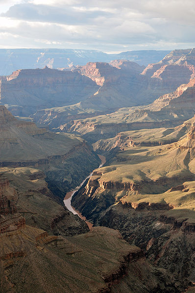